![](/images/other/stat-length.png)
![Excursión Senderismo Saint-Martin (VS) - - Photo](https://media.geolcdn.com/t/1900/400/ext.pjpeg?maxdim=2&url=https%3A%2F%2Fstatic1.geolcdn.com%2Fsiteimages%2Fupload%2Ffiles%2F1553511878bg_sport_marche.png)
lroux
Usuario
![Longitud](/images/other/stat-length.png)
![Altitud máxima](https://static1.geolcdn.com/siteimages/upload/files/1508320355ic_sort_altitude_max_24dp.png)
![Desnivel positivo](https://static1.geolcdn.com/siteimages/upload/files/1508320355ic_sort_den_pos_24dp.png)
![Km-Effort](/images/other/stat-length.png)
![Altitud mínima](https://static1.geolcdn.com/siteimages/upload/files/1508320355ic_sort_altitude_min_24dp.png)
![Desnivel negativo](https://static1.geolcdn.com/siteimages/upload/files/1508320355ic_sort_den_neg_24dp.png)
![Boucle](https://static1.geolcdn.com/siteimages/upload/files/16400158638029165_repeat_loop_refresh_sync_direction_icon.png)
![Senderismo](https://static1.geolcdn.com/sitytour/trail-icons/101.png)
6h18
Dificultad : Desconocido
![Escanee este código QR para abrir la excursión en la aplicación SityTrail](https://capi.geolives.com/qq0zvz2zws4bq2lad0pu/sitytour/trails/25449/qr.png?size=200)
Aplicación GPS de excursión GRATIS
A propósito
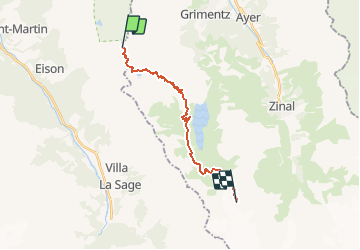
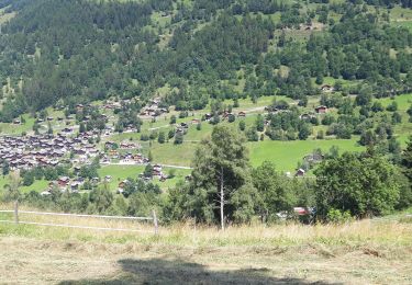
Ruta Senderismo de 16,4 km a descubrir en Vallés, Hérens, Saint-Martin (VS). Esta ruta ha sido propuesta por lroux.
Descripción
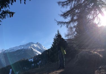
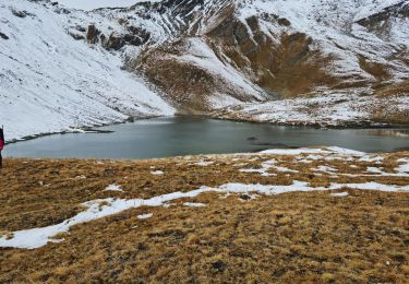
Passage par le Haut Chemin (2500m) qui longe le lac de Moiry par les hauts. Chemin très bien traçé ,spectaculaire. Arrêt pique-nique dans une prairie à l''embranchement du chemin du col du Tsaté, avant d'' entamer la descente pour prendre le chemin de la cabane,
Chantal, grdienne de la cabane des Bossons rend l''étape très agréable (56.-/ demi pension) .Un grand Leonberg vous accueille en aboyant sourdement pour vous souhaiter la bienvenue. Très doux, il impressionne, mais une fois le contact établi, on est sous bonne garde.
Localización
Comentarios
Excursiones cerca
![Excursión A pie Mont-Noble - La Combe - Nax - Photo](https://media.geolcdn.com/t/375/260/05728741-281c-4bbb-92b2-e33fe7322205.jpeg&format=jpg&maxdim=2)
![A pie A pie](https://static1.geolcdn.com/sitytour/trail-icons/100.png)
A pie
![](/images/other/stat-length.png)
![](https://static1.geolcdn.com/siteimages/upload/files/16400158638029165_repeat_loop_refresh_sync_direction_icon.png)
![Excursión A pie Mont-Noble - Le Louché Lac - Col du Cou - Photo](https://media.geolcdn.com/t/375/260/d60cf38c-77bf-4129-9294-d60e6b1dffc9.jpeg&format=jpg&maxdim=2)
![A pie A pie](https://static1.geolcdn.com/sitytour/trail-icons/100.png)
A pie
![](/images/other/stat-length.png)
![](https://static1.geolcdn.com/siteimages/upload/files/16400158638029165_repeat_loop_refresh_sync_direction_icon.png)
![Excursión A pie Mont-Noble - Le Louché-L'Ar du Tsan Lac (A) - Photo](https://media.geolcdn.com/t/375/260/d60cf38c-77bf-4129-9294-d60e6b1dffc9.jpeg&format=jpg&maxdim=2)
![A pie A pie](https://static1.geolcdn.com/sitytour/trail-icons/100.png)
A pie
![](/images/other/stat-length.png)
![](https://static1.geolcdn.com/siteimages/upload/files/16400158638029165_repeat_loop_refresh_sync_direction_icon.png)
![Excursión A pie Mont-Noble - L'Ar du Tsan - Le Louché Lac (B) - Photo](https://media.geolcdn.com/t/375/260/d60cf38c-77bf-4129-9294-d60e6b1dffc9.jpeg&format=jpg&maxdim=2)
![A pie A pie](https://static1.geolcdn.com/sitytour/trail-icons/100.png)
A pie
![](/images/other/stat-length.png)
![](https://static1.geolcdn.com/siteimages/upload/files/16400158638029165_repeat_loop_refresh_sync_direction_icon.png)
![Senderismo Senderismo](https://static1.geolcdn.com/sitytour/trail-icons/101.png)
Senderismo
![](/images/other/stat-length.png)
![](https://static1.geolcdn.com/siteimages/upload/files/16400158638029165_repeat_loop_refresh_sync_direction_icon.png)
![Excursión Senderismo Anniviers - barrage de moiry - Photo](https://media.geolcdn.com/t/375/260/b92986c7-0732-42f4-9954-e3868d779e32.jpg&format=jpg&maxdim=2)
![Senderismo Senderismo](https://static1.geolcdn.com/sitytour/trail-icons/101.png)
Senderismo
![](/images/other/stat-length.png)
![](https://static1.geolcdn.com/siteimages/upload/files/16400158638029165_repeat_loop_refresh_sync_direction_icon.png)
![Excursión A pie Evolène - Volvovron - L'A Vieille - Photo](https://media.geolcdn.com/t/375/260/5c03b540-8f8c-485d-804b-53ff835b3e8f.jpeg&format=jpg&maxdim=2)
![A pie A pie](https://static1.geolcdn.com/sitytour/trail-icons/100.png)
A pie
![](/images/other/stat-length.png)
![](https://static1.geolcdn.com/siteimages/upload/files/16400158638029165_repeat_loop_refresh_sync_direction_icon.png)
![Senderismo Senderismo](https://static1.geolcdn.com/sitytour/trail-icons/101.png)
Senderismo
![](/images/other/stat-length.png)
![](https://static1.geolcdn.com/siteimages/upload/files/16400158638029165_repeat_loop_refresh_sync_direction_icon.png)
![Excursión Senderismo Anniviers - Marché Bisse - Photo](https://media.geolcdn.com/t/375/260/78dd35b0-32a5-4036-bfdd-a50175690a27.jpg&format=jpg&maxdim=2)
![Senderismo Senderismo](https://static1.geolcdn.com/sitytour/trail-icons/101.png)
Senderismo
![](/images/other/stat-length.png)
![](https://static1.geolcdn.com/siteimages/upload/files/16400158638029165_repeat_loop_refresh_sync_direction_icon.png)